Definition
The Australian Statistical Geography Standard (ASGS) is a classification of Australia into a hierarchy of statistical areas. It is a social geography, developed to reflect the location of people and communities. It is used for the publication and analysis of official statistics and other data. The ASGS is updated every 5 years to account for growth and change in Australia’s population, economy and infrastructure.
For the 2021 release, the ASGS will be re-named to the Australian Statistical Geography Standard (ASGS) Edition 3. Until this point, the ASGS has been named according to the Census of Population and Housing year it referred to. This has led to confusion as the ASGS has historically been published across several years. For example, the Urban Centres and Localities publication for ASGS Edition 2 (2016) was published in 2017.
ASGS Edition 3 will be used for the 2021 Census of Population and Housing, and will be progressively introduced into other ABS data collections from 2022. ASGS Edition 3 is an update of ASGS Edition 2 (2016).
Classification Structure
The Main Structure of the Australian Statistical Geography Standard (ASGS) is developed by the ABS and is used to release and analyse a broad range of social, demographic and economic statistics. It is also widely used by other organisations. The structure is broadly based on the concept of a functional area. A functional area is an area within which many people commute or travel to access services.
The structure has seven hierarchical levels listed below in descending order:
- Australia (AUS)
- States and Territories (S/T)
- Statistical Areas Level 4 (SA4s)
- Statistical Areas Level 3 (SA3s)
- Statistical Areas Level 2 (SA2s)
- Statistical Areas Level 1 (SA1s)
- Mesh Blocks (MBs)
Each level directly aggregates to the level above. For example, SA1s are aggregates of Mesh Blocks and they in turn aggregate to SA2s. This principle continues up through the remaining levels of the hierarchy. At each hierarchical level, all of Geographic Australia is covered without gaps or overlaps.
Greater Capital City Statistical Areas (GCCSAs), while not a part of the Main Structure hierarchy, are geographic regions that are also designed to represent functional areas.
Classification Levels
| Name | Description | Code structure | # | |||||||||||||||
|---|---|---|---|---|---|---|---|---|---|---|---|---|---|---|---|---|---|---|
| Statistical Areas Level 4 (SA4s) | Statistical Area Level 4 (SA4s) are geographic areas built from whole Statistical Areas Level 3 (SA3s). SA4s are the largest sub-state regions in the Main Structure of the ASGS and are designed for the output of a variety of regional data, including data from the 2021 Census of Population and Housing. SA4 boundaries represent labour markets and the functional area of Australian capital cities respectively. They are designed with an emphasis on stability over time to support the time series of statistical releases such as the Quarterly Labour Force publication. These areas represent labour markets or groups of labour markets within each state and territory. Whole SA4s aggregate to Greater Capital City Statistical Areas and States and Territories. There are 108 SA4s covering the whole of Australia without gaps or overlaps. This includes 19 non-spatial special purpose codes including a new Outside Australia code. These non-spatial SA4s represent populations that are difficult to define geographically such as people who are in transit or have no fixed address. These are represented by Migratory – Offshore – Shipping and No Usual Address SA4s. The Other Territories of Jervis Bay, Cocos (Keeling) Islands, Christmas Island and Norfolk Island are together represented by a single SA4. |
SA4s are identified by a 3-digit hierarchical code. This comprises a 1-digit State or Territory identifier, which precedes a 2-digit SA4 identifier, unique within each State and Territory. Coding structure example for 102 Central Coast
|
0 | |||||||||||||||
| Statistical Areas Level 3 (SA3s) | Statistical Areas Level 3 (SA3s) are geographic areas built from whole Statistical Areas Level 2 (SA2s). They are designed for the output of regional data, including 2021 Census of Population and Housing data. SA3s create a standard framework for the analysis of ABS data at the regional level through clustering groups of SA2s that have similar regional characteristics. Whole SA3s aggregate to form Statistical Areas Level 4 (SA4s). |
SA3s are identified by 5-digit hierarchical codes. This comprises a 1-digit State or Territory identifier followed by a 2-digit SA4 identifier, unique within each State and Territory, and a 2-digit SA3 identifier, unique within each SA4. Coding structure example for 11401 Shoalhaven
|
0 | |||||||||||||||
| Statistical Areas Level 2 (SA2s) | Statistical Areas Level 2 (SA2s) are medium-sized general purpose areas built up from whole Statistical Areas Level 1 (SA1s). Their purpose is to represent a community that interacts together socially and economically. There are 2,473 SA2s covering the whole of Australia without gaps or overlaps. This includes 19 non-spatial special purpose codes including a new Outside Australia code. These non-spatial SA2s represent populations that are difficult to define geographically such as people who are in transit or have no fixed address. These are represented by Migratory – Offshore – Shipping and No Usual Address SA2s. SA2s are generally the smallest areas used for the release of ABS non-Census of Population and Housing statistics, including Estimated Resident Population and Health and Vitals data. Whole SA2s aggregate to form Statistical Areas Level 3 (SA3s). SA2s are also used to build Significant Urban Areas and to approximate Tourism Regions. |
An SA2 is identifiable by a 9-digit fully hierarchical code comprising the 1-digit State or Territory identifier, and Statistical Areas Level 2-4 identifiers. The SA2 identifier is a 4-digit code, assigned in alphabetical order within an SA3. An SA2 code is only unique within a State or Territory if it is preceded by the State or Territory identifier. Coding structure example for 503021295 East Perth
|
0 | |||||||||||||||
| Statistical Areas Level 1 (SA1s) | Statistical Areas Level 1 (SA1s) are geographic areas built from whole Mesh Blocks. Whole SA1s aggregate to form Statistical Areas Level 2 (SA2s). SA1s are designed to maximise the geographic detail available for Census of Population and Housing data. However, limited Census of Population and Housing data may also be available at the Mesh Block level for ASGS Edition 3. There are 61,845 SA1 regions covering the whole of Australia without gaps or overlaps. This includes 34 non-spatial special purpose codes including a new Outside Australia code. These non-spatial SA1s represent populations that are difficult to define geographically such as people who are in transit or have no fixed address. Examples include the Migratory and No Usual Address SA1s. SA1s are also used as the building blocks for some ASGS geographies, including the Indigenous Structure, Significant Urban Areas, Urban Centres and Localities, Section of State Structure, and the Remoteness Structure. |
SA1s are identified by an 11-digit fully hierarchical code, comprising the 1-digit State and Territory, and Statistical Areas Level 1-4 identifiers. The SA1 identifier is a 2-digit code, assigned within an SA2. An SA1 code is only unique within a State or Territory when it is preceded by the State or Territory identifier. Coding structure example for 50302104118
|
0 | |||||||||||||||
| Mesh Blocks (MBs) | Mesh Blocks are the smallest geographic areas defined by the ABS and form the building blocks for the larger regions of the Australian Statistical Geography Standard (ASGS). They broadly identify land use such as residential, commercial, primary production and parks. Statistical Areas Level 1 (SA1s) are generally the smallest geographic unit used to release Census of Population and Housing data; however, for ASGS Edition 3, limited Census of Population and Housing data may also be available at the Mesh Block level. ASGS Edition 3 contains 368,286 Mesh Blocks covering the whole of Australia without gaps or overlaps. This includes 114 non-spatial special purpose codes including a new Outside Australia code. These non-spatial Mesh Blocks represent populations that are difficult to define geographically such as people who are in transit or have no fixed address. Migratory and No Usual Address are examples of this type of Mesh Block. The Non ABS structures that will be approximated from Mesh Blocks include Local Government Areas, Postal Areas, Suburbs and Localities (formerly State Suburbs), Commonwealth Electoral Divisions, State Electoral Divisions, Australian Drainage Divisions and Destination Zones. As Mesh Blocks are very small they can be combined together to accurately approximate a large range of other geographies. |
The 11-digit Mesh Block code comprises: State and Territory identifier (1 digit), and a Mesh Block identifier (10 digits). Coding structure example for 60106840000
|
0 | |||||||||||||||
| Urban Centres and Localities (UCL) | Urban Centres and Localities (UCLs) represent areas of concentrated urban development. They are identified using dwelling and population density criteria and data from the 2021 Census of Population and Housing. Urban Centres and Localities are designed to facilitate the visualisation and analysis of statistical data, in particular data from the Census of Population and Housing. The criteria for inclusion (such as minimum population sizes) enable users to access cross classified Census data (such as population counts by various age ranges), without limiting the usability of the associated data. Urban Centres and Localities (UCL) are identifiable by 6-digit hierarchical codes. This is built from State/Territory (S/T), Section of State (SOS), Section of State Range (SOSR) and UCL identifiers. A UCL identifier is only unique if it is preceded by the state or territory, Section Of State and Section Of State Range identifiers. It is therefore possible to identify the population range to which the UCL belongs from the Section of State and Section of State Range codes. The key criteria for Urban Centre and Locality (UCL) names are that they be:
|
UCL coding structure
Non-spatial special purpose codes are also part of the Urban Centres and Localities classification.
|
0 |
Comments
ASGS diagram:
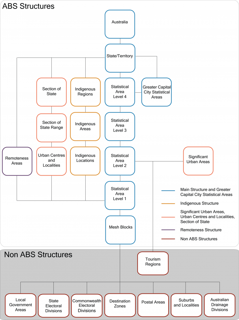
The diagram shows how different elements of the ASGS are related. The main building blocks of the ASGS are Mesh Blocks. Mesh Blocks build to SA1s which aggregate up to SA2s and so on in the following order from smallest to largest areas: Mesh Blocks, SA1s, SA2s, SA3s, SA4s, State/Territories and Australia. Greater Capital City Statistical Areas are published as part of the Main Structure and are built up from SA4s.
The smallest units of the Indigenous Structure, Indigenous Locations are built up from SA1s. Indigenous Locations aggregate up to Indigenous Areas and Indigenous Areas then aggregate up to Indigenous Regions. Most Non ABS Structures are built up from Mesh Blocks. This includes Postal Areas, Suburbs and Localities, Local Government Areas, State Electoral Divisions, Commonwealth Electoral Divisions, Australian Drainage Divisions and Destination Zones. Tourism Regions are the exception and are built up from SA2s. Urban Centres and Localities (UCLs) are built from SA1s.
The population contained within each UCL then determines which Section of State Region and Section of State each UCL is allocated to. Significant Urban Areas are built from SA2s and are designed to capture larger towns and cities. Remoteness Areas are built up from SA1s.
Origin
Australian Bureau of Statistics (Jul2021-Jun2026), Australian Statistical Geography Standard (ASGS) Edition 3, ABS Website, accessed 5 September 2024.
Related content
| Relation | Count |
|---|---|
| Value Domains referencing this Classification | 5 |